 Early Maps of Stevens County
Old Towns Map Project created by Map Metrics showing many communities not in existance today
USGenWeb Archives 1909 Crams Superior Map of Washington
Washington Digital Map Library
Spokane Indian Reservation 1910
Note: this map shows southern Stevens Co with names of property owners
Early Maps of Stevens County
Old Towns Map Project created by Map Metrics showing many communities not in existance today
USGenWeb Archives 1909 Crams Superior Map of Washington
Washington Digital Map Library
Spokane Indian Reservation 1910
Note: this map shows southern Stevens Co with names of property owners
To view current map click
here
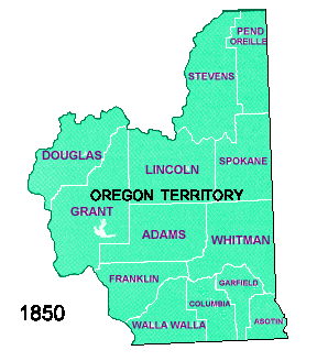 White boundaries indicate current boundaries.
Black boundaries indicate 1850 boundaries.
White boundaries indicate current boundaries.
Black boundaries indicate 1850 boundaries.
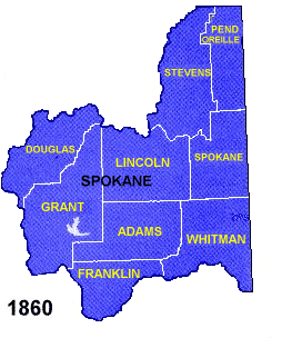 White boundaries indicate current boundaries.
Black boundaries indicate 1860 boundaries.
This first Spokane County Later Became Stevens
County.
White boundaries indicate current boundaries.
Black boundaries indicate 1860 boundaries.
This first Spokane County Later Became Stevens
County.
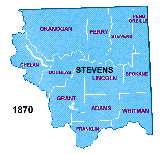 White boundaries indicate current boundaries.
Black boundaries indicate 1870 boundaries.
White boundaries indicate current boundaries.
Black boundaries indicate 1870 boundaries.
 White boundaries indicate current boundaries.
Black boundaries indicate 1880 boundaries.
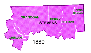
White boundaries indicate current boundaries.
Black boundaries indicate 1880 boundaries.
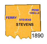 White boundaries indicate current boundaries.
Black boundaries indicate 1890 boundaries.
White boundaries indicate current boundaries.
Black boundaries indicate 1890 boundaries.
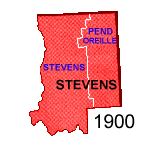 White boundaries indicate current boundaries.
Black boundaries indicate 1900 boundaries.
Pend Oreille County was created in 1911.
White boundaries indicate current boundaries.
Black boundaries indicate 1900 boundaries.
Pend Oreille County was created in 1911.
Return to Stevens County Home page
Maintained by Susan Dechant Stevens County Coordinator.
|